Rural Health
Resources by Type: Map/Mapping System
North Carolina State Designated Rural Health Centers: SFY 2026
North Carolina map showing Rural Health Center site county coverage and locations of the 18 state designated Rural Health Center sites.
Date: 07/2025
Sponsoring organization: North Carolina Department of Health and Human Services
view details
North Carolina map showing Rural Health Center site county coverage and locations of the 18 state designated Rural Health Center sites.
Date: 07/2025
Sponsoring organization: North Carolina Department of Health and Human Services
view details
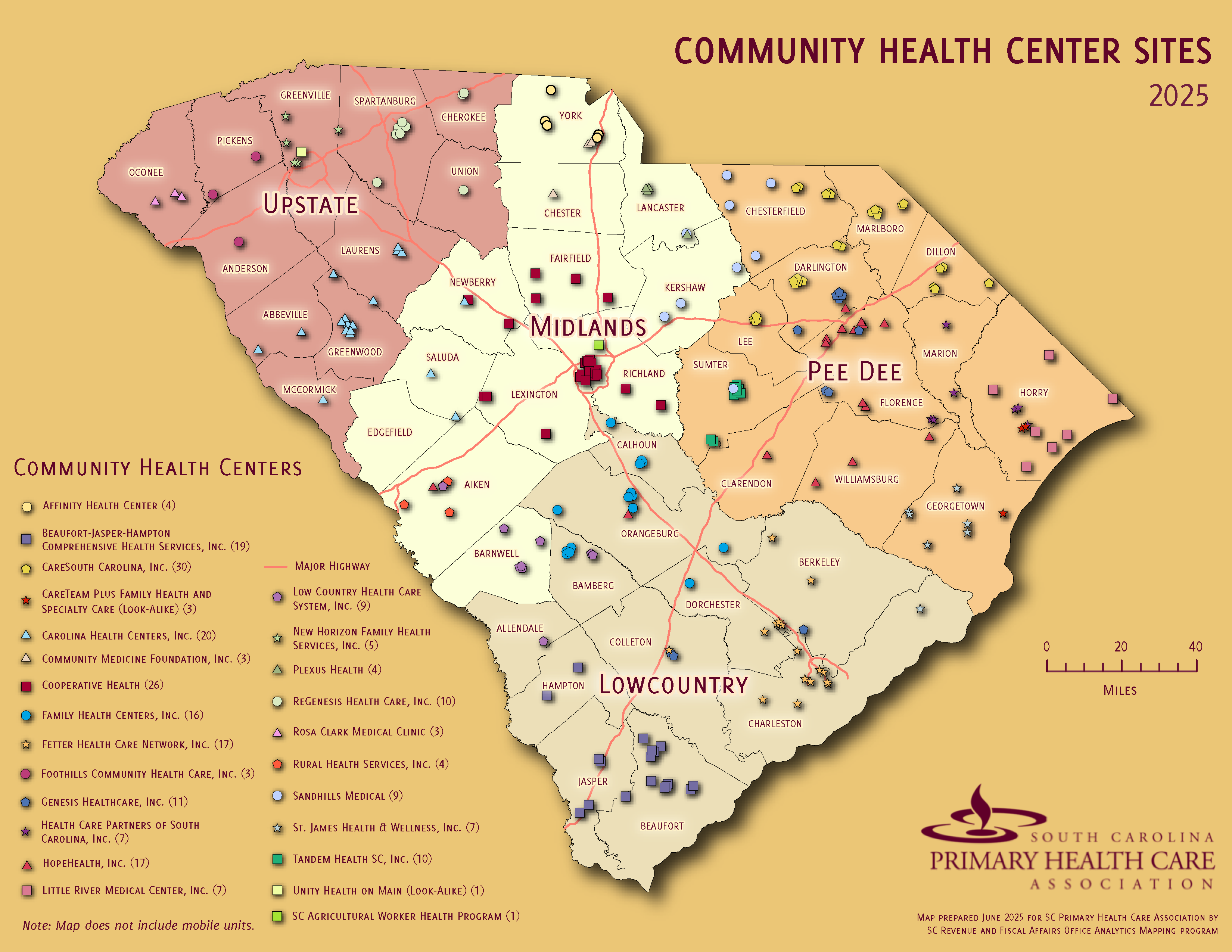
South Carolina Community Health Center Sites 2025
County-level South Carolina map showing names and locations of Community Health Center sites.
Date: 06/2025
Sponsoring organization: South Carolina Primary Health Care Association
view details
County-level South Carolina map showing names and locations of Community Health Center sites.
Date: 06/2025
Sponsoring organization: South Carolina Primary Health Care Association
view details
Most Recreation-Concentrated Counties Located Near Coasts, Lakes, and Mountains
Map showing rural and urban counties with a high combined share of vacation housing and of earnings and employment in arts, entertainment, and recreation; accommodation and food services; and real estate and rental and leasing services.
Date: 06/2025
Sponsoring organization: USDA Economic Research Service
view details
North Carolina Primary Care - Health Professional Shortage Areas (HPSA)
County-level map of Primary Care Health Professional Shortage Areas (HPSAs) in North Carolina, with shadings showing ranges of HPSA scores.
Date: 06/2025
Sponsoring organization: North Carolina Office of Rural Health
view details
County-level map of Primary Care Health Professional Shortage Areas (HPSAs) in North Carolina, with shadings showing ranges of HPSA scores.
Date: 06/2025
Sponsoring organization: North Carolina Office of Rural Health
view details
Rate of Population Change in Nonmetropolitan Counties, 2020-2024
Map identifying which nonmetro counties gained population and which lost population between 2020 and 2024.
Author(s): John Cromartie, Justin B. Winikoff
Date: 06/2025
Sponsoring organization: USDA Economic Research Service
view details
Map identifying which nonmetro counties gained population and which lost population between 2020 and 2024.
Author(s): John Cromartie, Justin B. Winikoff
Date: 06/2025
Sponsoring organization: USDA Economic Research Service
view details
County Economic Status in Appalachia, FY 2026
Shows levels of economic distress in Appalachian counties based on unemployment rates, income, and poverty levels. Includes interactive map, downloadable maps and data files, and data report.
Date: 05/2025
Sponsoring organization: Appalachian Regional Commission
view details
Shows levels of economic distress in Appalachian counties based on unemployment rates, income, and poverty levels. Includes interactive map, downloadable maps and data files, and data report.
Date: 05/2025
Sponsoring organization: Appalachian Regional Commission
view details
Arkansas Hospitals, 2025
Map of Arkansas identifying the names and locations of acute care hospitals, Critical Access Hospitals, and Rural Emergency Hospitals.
Date: 04/2025
Sponsoring organization: Arkansas Foundation for Medical Care (AFMC)
view details
Map of Arkansas identifying the names and locations of acute care hospitals, Critical Access Hospitals, and Rural Emergency Hospitals.
Date: 04/2025
Sponsoring organization: Arkansas Foundation for Medical Care (AFMC)
view details
New Mexico MMR Vaccine Coverage for Adults by County, 2025
Provides maps on current measles, mumps, and rubella (MMR) vaccination coverage among adults in New Mexico.
Date: 04/2025
Sponsoring organization: New Mexico Department of Health
view details
Provides maps on current measles, mumps, and rubella (MMR) vaccination coverage among adults in New Mexico.
Date: 04/2025
Sponsoring organization: New Mexico Department of Health
view details
Critical Access Hospitals in Arkansas, 2025
Map showing names and locations of Arkansas Critical Access Hospitals (CAHs).
Date: 04/2025
Sponsoring organization: Arkansas Hospital Association
view details
Map showing names and locations of Arkansas Critical Access Hospitals (CAHs).
Date: 04/2025
Sponsoring organization: Arkansas Hospital Association
view details
Plains and Southeast Areas Received Largest Share of Federal Community Facilities Program's Rural Hospital Funding, 2000 to 2020
Map comparing the amount of Community Facilities Program's rural hospital funding with rural hospital closures between 2000 and 2020 in the 8 Bureau of Economic Analysis geographic regions.
Author(s): Anil Rupasingha
Date: 04/2025
Sponsoring organization: USDA Economic Research Service
view details
Map comparing the amount of Community Facilities Program's rural hospital funding with rural hospital closures between 2000 and 2020 in the 8 Bureau of Economic Analysis geographic regions.
Author(s): Anil Rupasingha
Date: 04/2025
Sponsoring organization: USDA Economic Research Service
view details