Rural Health
Resources by Type: Map/Mapping System
American Indian and Alaska Native Population for Nonmetropolitan Counties
Printable map that shows the percent of the U.S. population by county who are American Indian or Alaska Native. Data source: U.S. Census Bureau, American Community Survey (ACS) 5-Year Estimates
Date: 01/2026
Sponsoring organization: Rural Health Information Hub
view details
Printable map that shows the percent of the U.S. population by county who are American Indian or Alaska Native. Data source: U.S. Census Bureau, American Community Survey (ACS) 5-Year Estimates
Date: 01/2026
Sponsoring organization: Rural Health Information Hub
view details
Black or African American Population for Nonmetropolitan Counties
Printable map that shows the percent of the U.S. population by county who are Black or African American. Data source: U.S. Census Bureau, American Community Survey (ACS) 5-Year Estimates
Date: 01/2026
Sponsoring organization: Rural Health Information Hub
view details
Printable map that shows the percent of the U.S. population by county who are Black or African American. Data source: U.S. Census Bureau, American Community Survey (ACS) 5-Year Estimates
Date: 01/2026
Sponsoring organization: Rural Health Information Hub
view details
Skilled Nursing Facilities - Dually Certified in Rural Areas
Printable map that shows the location of Skilled Nursing Facilities (SNFs) and nursing facilities that are dually certified located in rural areas (outside U.S. Census Bureau Urban Areas with a population of 50,000 or more). Data source: data.HRSA.gov, U.S. Department of Health and Human Services
Additional links: Dually Certified Rural SNF Table
Date: 01/2026
Sponsoring organization: Rural Health Information Hub
view details
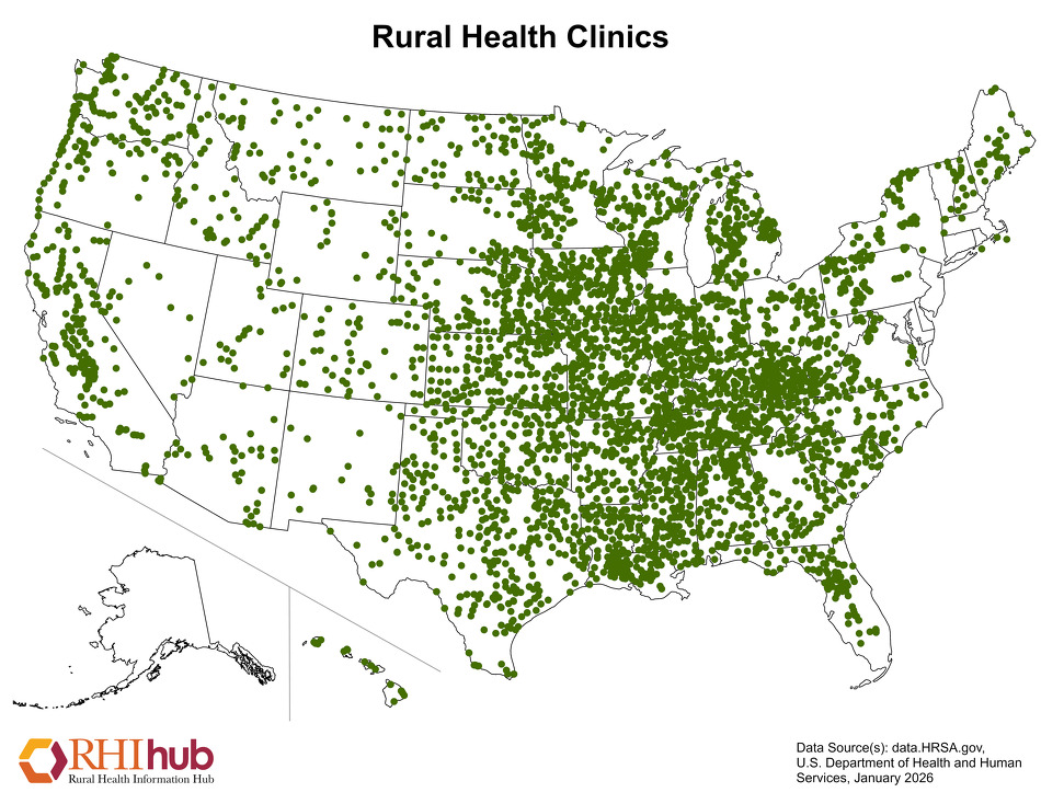
Rural Health Clinics (RHCs)
Printable map that shows the location of Rural Health Clinics (RHCs) nationwide by state. Data source: data.HRSA.gov, U.S. Department of Health and Human Services
Additional links: RHC Facility Table
Date: 01/2026
Sponsoring organization: Rural Health Information Hub
view details
Printable map that shows the location of Rural Health Clinics (RHCs) nationwide by state. Data source: data.HRSA.gov, U.S. Department of Health and Human Services
Additional links: RHC Facility Table
Date: 01/2026
Sponsoring organization: Rural Health Information Hub
view details
Population Under Age 18 by County
Printable map that shows the percent of population in the U.S. by county who are under 18 years of age. Data source: U.S. Census Bureau, American Community Survey (ACS) 5-Year Estimates
Date: 01/2026
Sponsoring organization: Rural Health Information Hub
view details
Printable map that shows the percent of population in the U.S. by county who are under 18 years of age. Data source: U.S. Census Bureau, American Community Survey (ACS) 5-Year Estimates
Date: 01/2026
Sponsoring organization: Rural Health Information Hub
view details
Population with Disabilities for Nonmetropolitan Counties
Printable map that shows the percent of population with disabilities nationwide by county. Data source: U.S. Census Bureau, American Community Survey (ACS) 5-Year Estimates
Date: 01/2026
Sponsoring organization: Rural Health Information Hub
view details
Printable map that shows the percent of population with disabilities nationwide by county. Data source: U.S. Census Bureau, American Community Survey (ACS) 5-Year Estimates
Date: 01/2026
Sponsoring organization: Rural Health Information Hub
view details
Hispanic/Latino Populations for Nonmetropolitan Counties
Printable map that shows the percent of the U.S. population by county who are Hispanic or Latino. Data source: U.S. Census Bureau, American Community Survey (ACS) 5-Year Estimates
Date: 01/2026
Sponsoring organization: Rural Health Information Hub
view details
Printable map that shows the percent of the U.S. population by county who are Hispanic or Latino. Data source: U.S. Census Bureau, American Community Survey (ACS) 5-Year Estimates
Date: 01/2026
Sponsoring organization: Rural Health Information Hub
view details
Federally Qualified Health Center Sites in Rural Areas
Printable map that shows the location of Federally Qualified Health Center (FQHC) sites that are located in rural areas (outside U.S. Census Bureau Urban Areas with a population of 50,000 or more). Data source: data.HRSA.gov, U.S. Department of Health and Human Services
Additional links: Rural FQHC Facility Table
Date: 01/2026
Sponsoring organization: Rural Health Information Hub
view details
Population Aged 65 and Older by County
Printable map that shows the percent of population who are 65 years or older nationwide by county. Data source: U.S. Census Bureau, American Community Survey (ACS) 5-Year Estimates
Date: 01/2026
Sponsoring organization: Rural Health Information Hub
view details
Printable map that shows the percent of population who are 65 years or older nationwide by county. Data source: U.S. Census Bureau, American Community Survey (ACS) 5-Year Estimates
Date: 01/2026
Sponsoring organization: Rural Health Information Hub
view details
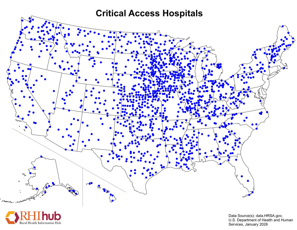
Critical Access Hospitals (CAHs)
Printable map that shows the location of Critical Access Hospitals (CAHs) nationwide by state. Data source: data.HRSA.gov, U.S. Department of Health and Human Services
Additional links: CAH Facility Table
Date: 01/2026
Sponsoring organization: Rural Health Information Hub
view details
Printable map that shows the location of Critical Access Hospitals (CAHs) nationwide by state. Data source: data.HRSA.gov, U.S. Department of Health and Human Services
Additional links: CAH Facility Table
Date: 01/2026
Sponsoring organization: Rural Health Information Hub
view details