Rural Health
Resources by Topic: County-by-county data
Disability in America: People with Disabilities in Poverty (2017)
Displays the poverty rate among people with disabilities on the county level using data from the 2013-2017 American Community Survey (ACS).
Date: 01/2019
Sponsoring organization: Research and Training Center on Disability in Rural Communities
view details
Displays the poverty rate among people with disabilities on the county level using data from the 2013-2017 American Community Survey (ACS).
Date: 01/2019
Sponsoring organization: Research and Training Center on Disability in Rural Communities
view details
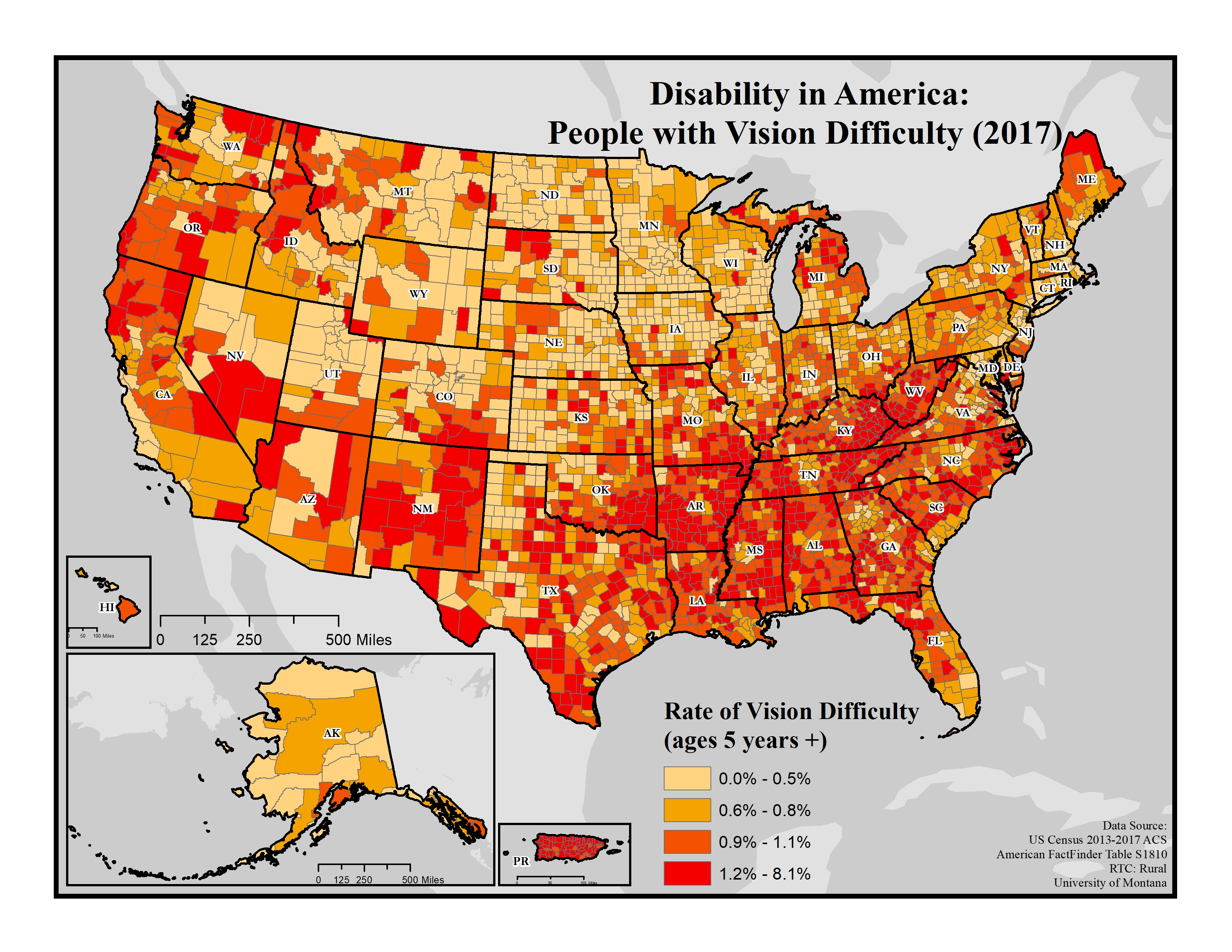
Disability in America: People with Vision Difficulty (2017)
Displays the rate of people with vision difficulty on the county level using data from the 2013-2017 American Community Survey (ACS).
Date: 01/2019
Sponsoring organization: Research and Training Center on Disability in Rural Communities
view details
Displays the rate of people with vision difficulty on the county level using data from the 2013-2017 American Community Survey (ACS).
Date: 01/2019
Sponsoring organization: Research and Training Center on Disability in Rural Communities
view details
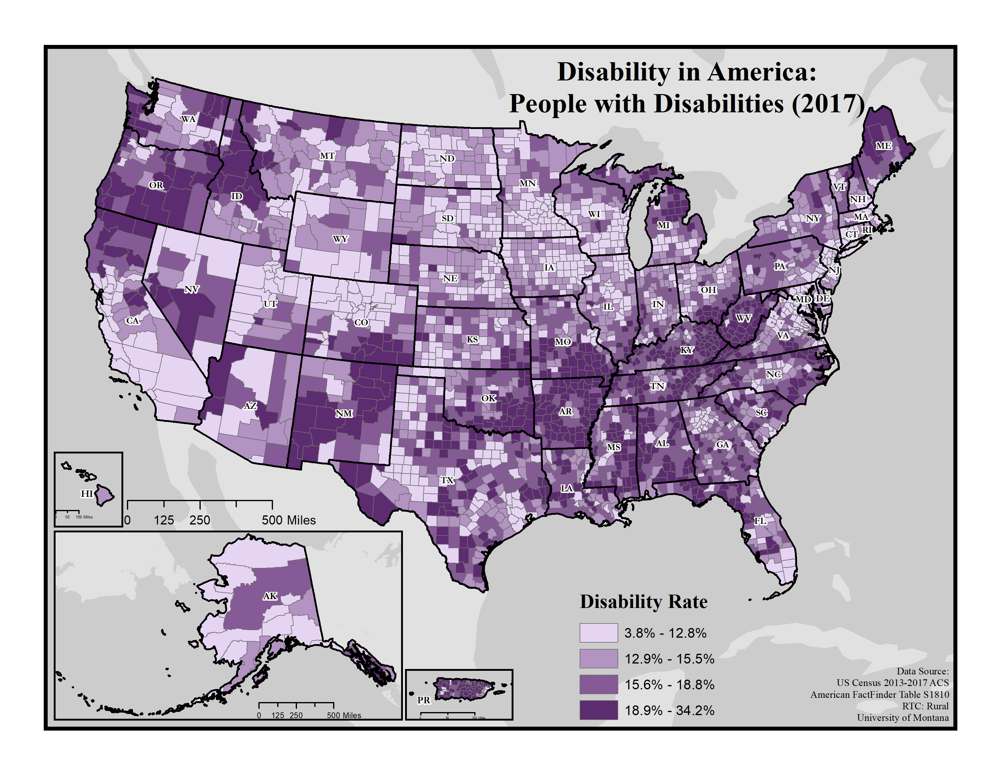
Disability in America: People with Disabilities (2017)
Displays general disability rates on the county level using data from the 2013-2017 American Community Survey (ACS).
Date: 01/2019
Sponsoring organization: Research and Training Center on Disability in Rural Communities
view details
Displays general disability rates on the county level using data from the 2013-2017 American Community Survey (ACS).
Date: 01/2019
Sponsoring organization: Research and Training Center on Disability in Rural Communities
view details
Oklahoma Drug Induced Causes of Death Due to Opioid Poisoning, 1999 to 2017
County-level map of Oklahoma, using data from the Centers for Disease Control and Prevention/National Center for Health Statistics, to show drug induced age-adjusted mortality rate due to opioid poisoning from 1999 to 2017.
Date: 01/2019
Sponsoring organization: Oklahoma State University Center for Rural Health
view details
Iowa Dentist Workforce Atlas, 1997-2016: 20 Years of the Iowa Dentist Tracking System
Provides detailed data on Iowa's dentists over time, including rural/urban comparisons. Addresses workforce trends, shortage areas, county-level data, historical data, and dentist migration.
Author(s): Raymond A. Kuthy, Susan C. McKernan, Julie C. Reynolds
Date: 01/2019
Sponsoring organization: Center for Social Science Innovation
view details
An Analysis of the Economic Impact of Missouri Physicians
Provides an overview on the economic impact of physicians in Missouri, with a focus on physician specialties, education, employment and salary conditions, and the economic inputs and outputs related to physicians. Includes rural versus urban physician economic impacts as well as county-level data on doctors of medicine (MDs), doctors of osteopathic medicine (DOs), physicians, and multi-specialty physicians, among other data.
Author(s): David M. Mitchell
Date: 2019
Sponsoring organization: Missouri Hospital Association
view details
Missouri's Health Care Workforce: Providing Care and Opportunity
Provides information on Missouri's healthcare workforce, including current demand and projected demand, healthcare education, projection of future healthcare needs, and more. Includes data on job postings in rural versus urban areas as well as county-level information on licensed practical nurses (LPNs), registered nurses (RNs), average age of citizens, net commuters, and projected percent change in demand for healthcare from 2017 to 2030, among other data.
Author(s): Jill Williams, David M. Mitchell
Date: 2019
Sponsoring organization: Missouri Hospital Association
view details
The Ecology of Neonatal Abstinence Syndrome
Summarizes results from an 8-state study of neonatal abstinence syndrome (NAS), a drug withdrawal condition that may occur in newborns exposed to opioids during pregnancy. Discusses correlations to rurality, unemployment rates, poverty, and the supply of healthcare providers, and identifies potential policy interventions that could help. For interactive, county-level data, see the Simulation of County Neonatal Abstinence Syndrome (NAS) Rates Tool based on study findings.
Additional links: Simulation of County Neonatal Abstinence Syndrome (NAS) Rates Tool
Date: 2019
Sponsoring organization: RAND Corporation
view details
Percentage of Households With Subscription to Any Broadband Service: 2013-2017
National map showing household broadband subscription rates by county.
Additional links: Completely Rural Counties, Mostly Rural Counties, Mostly Urban Counties
Date: 12/2018
Sponsoring organization: U.S. Census Bureau
view details
National map showing household broadband subscription rates by county.
Additional links: Completely Rural Counties, Mostly Rural Counties, Mostly Urban Counties
Date: 12/2018
Sponsoring organization: U.S. Census Bureau
view details
Arkansas Medicaid Program Overview SFY 2017
Provides an overview of Arkansas's Medicaid program, including county-level data on enrolled and participating providers, program enrollees, Medicaid expenditures, and waiver beneficiaries on pages 32-35.
Date: 12/2018
Sponsoring organization: Arkansas Department of Human Services
view details
Provides an overview of Arkansas's Medicaid program, including county-level data on enrolled and participating providers, program enrollees, Medicaid expenditures, and waiver beneficiaries on pages 32-35.
Date: 12/2018
Sponsoring organization: Arkansas Department of Human Services
view details