Rural Health
Resources by Type: Map/Mapping System
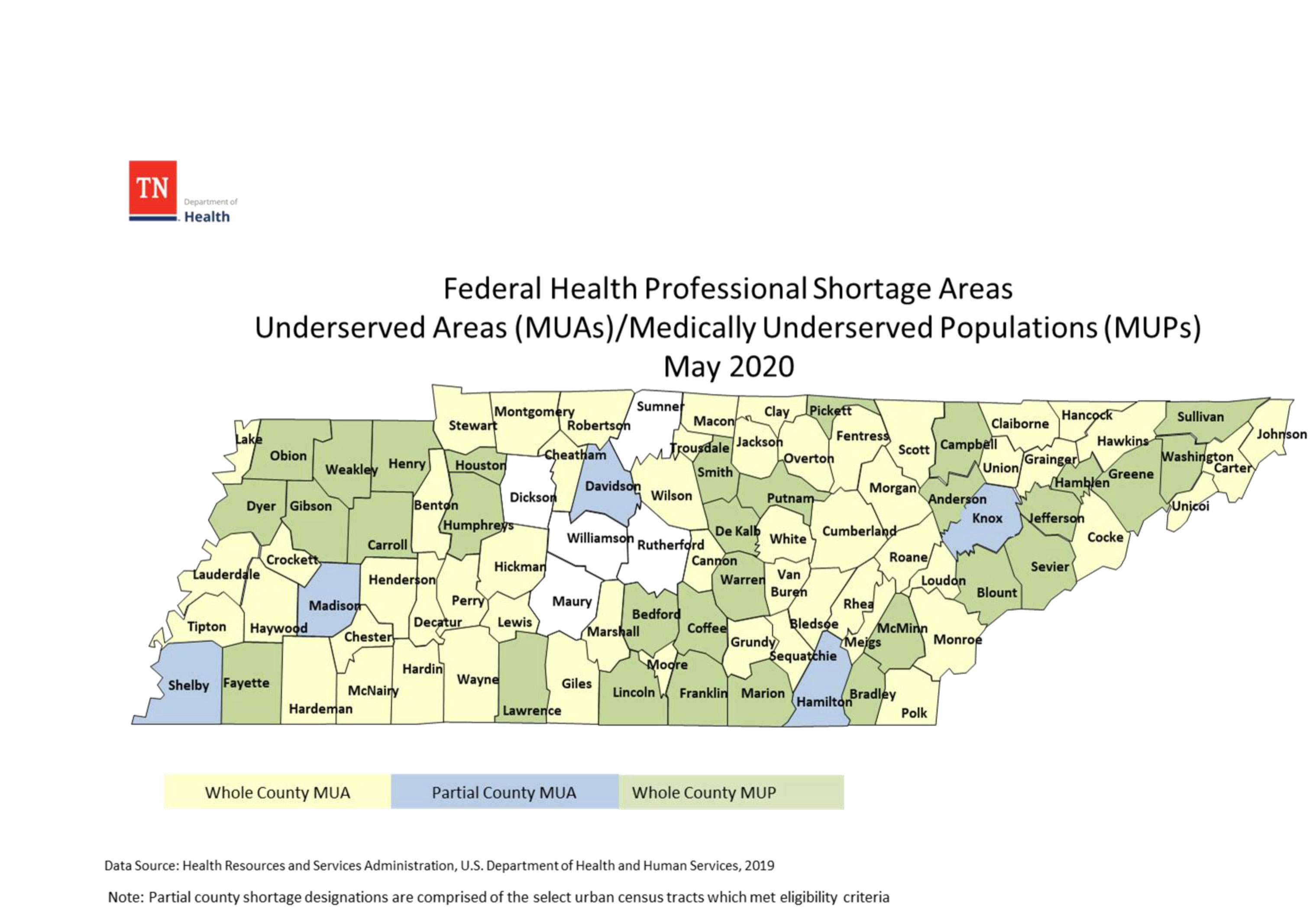
Tennessee Federal Health Professional Shortage Areas: Underserved Areas (MUAs)/Medically Underserved Populations (MUPs)
Map with shadings showing whole county or partial county Medically Underserved Areas and whole county Medically Underserved Populations.
Date: 05/2020
Sponsoring organization: Tennessee Department of Health
view details
Map with shadings showing whole county or partial county Medically Underserved Areas and whole county Medically Underserved Populations.
Date: 05/2020
Sponsoring organization: Tennessee Department of Health
view details
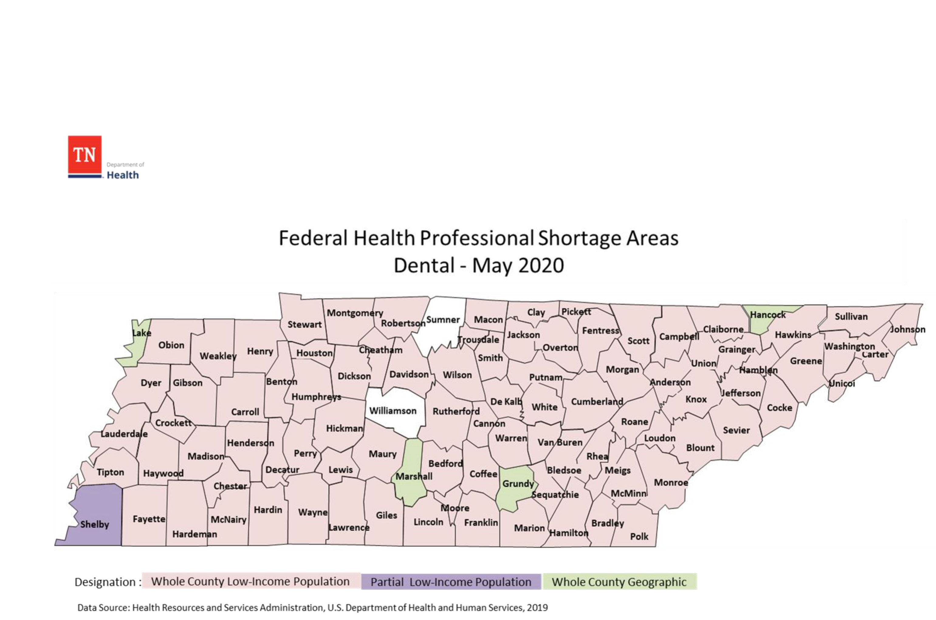
Tennessee Federal Health Professional Shortage Areas: Dental
County-level map with shadings showing low-income population or geographic Dental Health Professional Shortage Areas.
Date: 05/2020
Sponsoring organization: Tennessee Department of Health
view details
County-level map with shadings showing low-income population or geographic Dental Health Professional Shortage Areas.
Date: 05/2020
Sponsoring organization: Tennessee Department of Health
view details
Tennessee Federal Health Professional Shortage Areas: Primary Care
County-level map with shadings showing low-income population or geographic Primary Care Health Professional Shortage Areas.
Date: 05/2020
Sponsoring organization: Tennessee Department of Health
view details
County-level map with shadings showing low-income population or geographic Primary Care Health Professional Shortage Areas.
Date: 05/2020
Sponsoring organization: Tennessee Department of Health
view details
Idaho Rural Physician Incentive Program (RPIP) FY21 Eligible Areas
County-level map with shadings showing geographic Health Professional Shortage Areas (HPSAs), population group HPSAs, and ineligible areas.
Date: 04/2020
Sponsoring organization: Idaho Department of Health and Welfare
view details
County-level map with shadings showing geographic Health Professional Shortage Areas (HPSAs), population group HPSAs, and ineligible areas.
Date: 04/2020
Sponsoring organization: Idaho Department of Health and Welfare
view details
Idaho Rural Health Care Access Program (RHCAP) FY21 Primary Care Eligible Areas
County-level map with shadings showing primary care geographic Health Professional Shortage Areas (HPSAs), population group HPSAs, and ineligible areas.
Date: 04/2020
Sponsoring organization: Idaho Department of Health and Welfare
view details
County-level map with shadings showing primary care geographic Health Professional Shortage Areas (HPSAs), population group HPSAs, and ineligible areas.
Date: 04/2020
Sponsoring organization: Idaho Department of Health and Welfare
view details
Idaho Rural Health Care Access Program (RHCAP) FY21 Dental Health Eligible Areas
County-level map with shadings showing dental geographic Health Professional Shortage Areas (HPSAs), population group HPSAs, and ineligible areas.
Date: 04/2020
Sponsoring organization: Idaho Department of Health and Welfare
view details
County-level map with shadings showing dental geographic Health Professional Shortage Areas (HPSAs), population group HPSAs, and ineligible areas.
Date: 04/2020
Sponsoring organization: Idaho Department of Health and Welfare
view details
Indian Health Service Hospitals, Tribal Operated (PL 638) Sites and Urban Indian Health Centers in Arizona
Presents a map of Arizona highlighting the Indian Health Services (IHS) and tribal operated healthcare facilities throughout the state. Differentiates between Phoenix, Tucson, and Navajo area IHS facilities, tribal operated facilities, and Urban Indian Health Centers.
Date: 04/2020
Sponsoring organization: Arizona Center for Rural Health
view details
Community Pharmacies in Wisconsin
Map showing actively-licensed, community pharmacies in Wisconsin counties. Includes locations for chain pharmacies, independent pharmacies, and clinic/outpatient/HMO pharmacies based on data from October 2019.
Date: 04/2020
Sponsoring organizations: University of Wisconsin Madison School of Pharmacy, Wisconsin Office of Rural Health
view details
Percent Population Change by County and Municipio: 2010 to 2019
Map showing the percent population change in each county from 2010 to 2019.
Date: 03/2020
Sponsoring organization: U.S. Census Bureau
view details
Map showing the percent population change in each county from 2010 to 2019.
Date: 03/2020
Sponsoring organization: U.S. Census Bureau
view details
Numeric Population Change by County and Municipio: 2010 to 2019
Map showing the change in the number of people living in each county from 2010 to 2019.
Date: 03/2020
Sponsoring organization: U.S. Census Bureau
view details
Map showing the change in the number of people living in each county from 2010 to 2019.
Date: 03/2020
Sponsoring organization: U.S. Census Bureau
view details